

The problem
Overfishing is one of the most significant drivers of the decline in oceanic biodiversity across the world. It occurs when vessels catch fish faster than fish stocks can replenish (reproduce). 1 in every 5 fish sold is caught illegally, where these illegal catches amount to $23.5 billion [1]. 90% of the world’s fish stocks are fished at maximum capacity and one-third of fish stocks are no longer biologically sustainable [1]. This behaviour poses a risk to the entire oceanic ecosystem, which is essential for producing the oxygen we breathe daily.
The solution
Fortunately, OceanMind aim to solve this problem. OceanMind is a non-profit which uses satellites and artificial intelligence to reduce the level of unregulated overfishing. It achieves this by working with governments and local authorities to identify non-compliant action in the seas. In 2019, OceanMind joined Microsoft’s AI for Earth program [2], opening the scope and resource for tackling this Grand Challenge. In partnering with Microsoft, OceanMind is now able to process the world’s vessel tracking data in real-time, providing timely recommendations to local authorities on the compliance of fishing activities.
Moving towards serverless computing
With a limited number of employees, the sheer amount of data involved with tracking vessels previously required the firm to pay very high operating and maintenance costs just to keep servers running. Now, OceanMind uses the cloud-based solution Microsoft Azure. The reason for choosing Azure, apart from its reputation for scale, reliability, and security, was the need to adhere to data compliance laws. Maintaining compliance to regulation laws is critical when working with law enforcement agencies around the world, and Microsoft Azure has over 90 compliance certifications which make it the ideal provider for this international task [3].
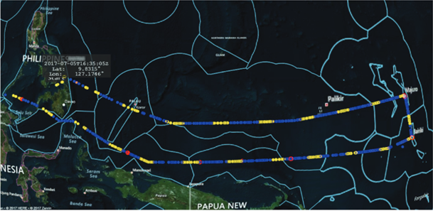
Using Azure, OceanMind can locate ships that have been in contact for a certain amount of time. This is done through geospatial processing of data from each ship’s Automatic Identification System (AIS). Larger vessels are legally required to carry an AIS for safety reasons [4]. Each signal transmitted by the AIS contains an identification code which specifies the purpose of the ship. If a ship attempts to manipulate the information transmitted by the system, movement tracking alone can still pick out rogue vessels. For example, if the signal and vessel tracks imply the vessel is a cargo ship, but the vessel is travelling in circles or a slow speed which is typical for fishing rather than transit, such suspicious behaviour would be flagged by the AI system (which is trained on normal behaviour) for investigation by the analysts.
Satellite Data
In cases where vessels turn off their tracking systems, satellite imagery is used, more specifically, synthetic aperture radar (SAR) technology. SAR can create three-dimensional reconstructions of objects, using radio waves. Successive pulses of radio waves are transmitted to a possible target scene and the echo of each pulse is received and recorded. As the SAR device moves with the spacecraft it is on, the antenna location changes relative to the target. Processing these successive radar echoes from multiple antenna positions allows for the creation of high-resolution multi-dimensional images of vessels (i.e., geospatial data).
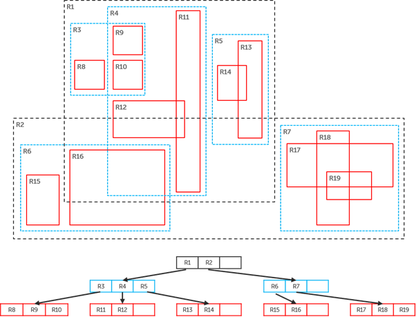
The nature of geospatial data does not allow it to be stored in a standard pandas DataFrame (a typical format for data in Python). For this data, OceanMind needed a new way of storing data that could be updated frequently and cost-efficiently. For this task, OceanMind uses a special form of R-Trees. The idea of an R-tree, first proposed by Antonin Guttman in 1984, is to group nearby objects and represent them with their minimum bounding rectangle (Figure 2). Overlapping boxes thus represent segments of the vessel tracks which were near one another, forming candidates for the proximity analysis. To ensure efficiency with continuous updates, OceanMind uses the R-Tree with Update Memos (RUM tree) which reduces the cost of object updates [5].
From this analysis, a proximity alert is generated when two or more vessels are close to each other for a period. These events then power the ML algorithm and detect illegal activities. The estimated computation cost for the solution totalled less than £10 a month [7]. The AI parses through billions of data points to single out non-compliant vessels, detecting suspected illegal fishing activities. It can state the type of fishing identified, the exact time and it happened, the type of vessel suspected undergoing the activity and the exact regulation broken.
Case Study: Thailand
Nowadays, fishing vessels in Thailand catch only 14% of the amount they previously caught in the 1960s [6]. The unsustainable rate of fishing was addressed by OceanMind which provided monitoring, surveillance advice, and direct support to the Royal Thai Department of Fisheries. This allowed the Royal Thai Government to completely reform its fisheries regulations, through the development of a new Fisheries Management Centre and greatly increased effective control over the Thai-flagged fishing fleet. As a result of its efforts, the Royal Thai Government was able to transition from an EU Yellow Card to a Green Card in the short space of 3 years [8].
What’s next?
The technology is being adapted to move beyond fishing, and the AI is being trained to detect human trafficking and modern slavery on fishing vessels. With funding from Microsoft, OceanMind now has the capacity to end modern slavery on the oceans within 10 years. Beyond the tracking of fishing vessels, satellite technology offers many ways of solving other problems such as ecology and conservation. For example, a study was carried out on the Antarctic seafloor, where researchers measured sea surface chlorophyll concentrations in combination with water and sediment sampling to study the ecology of the area [9]. Their model enabled the prediction of important components of seafloor diversity for large areas, allowing for better-informed conservation and management decisions.
References
[1] Endjin, 2020. OceanMind. Available at: https://endjin.com/who-we-help/customers/oceanmind/
[2] Microsoft, 2021. AI for Earth. Available at: https://www.microsoft.com/en-us/ai/ai-for-earth
[3] Microsoft, 2020. endjin helps OceanMind fight illegal fishing and human trafficking with Microsoft Azure. Available at: https://partner.microsoft.com/en-us/case-studies/endjin
[4] Gross, M., 2018. Eyes on our planet. Current Biology, Volume 28, Issue 3, 5 February 2018, pp. 89-92.
[5] Shi, Y., Hendawi A.M., Gupta J., Fattah, H., & Ali, M., 2016. RxSpatial: Reactive Spatial Library for Real-Time Location Tracking and Processing. Proceedings of the 2016 International Conference on Management of Data, pp. 2165-2168.
[6] Weeboon, 2018. Overfishing in Thailand. Available at: http://blog.weeboon.com/overfishing-in-thailand/#:~:text=Since 1966%2C Thai waters are,even longer on the ocean.
[7] Eve, C., 2020. Building a proximity detection pipeline. Endjin.com. Available at: https://endjin.com/blog/2020/04/building-a-proximity-detection-pipeline
[8] OceanMind, 2020. Governments and Authorities. Available at: https://www.oceanmind.global/authorities/
[9] Jansen, J. et. Al., 2017. Abundance and richness of key Antarctic seafloor fauna correlates with modelled food availability. Nat Ecol Evol, pp. 71-80.